my book with pictures
chapter-1/6 -
The Plate tectonic explanation,
said for the distribution of fossils is proved to be wrong.

The wrong interpretations given by the geologists for the occurrences of earthquakes and tsunamis have come to limelight with evidence. Particularly, the geologists believe that the continents are drifting as separate tectonic plates along with the sea floor around them.
Based on this theory, the geologists believe that earthquakes are caused when the edges of the moving tectonic plates rub against each other.
Similarly, tsunamis form when one tectonic plate passes under another tectonic plate.
This is called plate tectonic a modified theory of ''Continental Drift theory”.
This Continental Drift theory was first set forth by Dr. Alfred Wegener, a meteorologist. One day he happened to read an article in the library of the college where he was working.
This article mentioned about the existence of fossils of the same type of vegetation and animals in the continents of America and Europe, which were separated by the Atlantic Ocean, and an explanation had been offered stating that the reason for the presence of such fossils was, once upon a time there existed a temporary land bridge in the Atlantic Ocean region and later this land bridge might have got submerged under the ocean.
This theory did not satisfy Wegener.
He noticed the parallel setting of the edges of the continents situated on both the sides of the Atlantic Ocean.
Based on this setting, he believed that eons ago, these continents must have been a single mass of a vast land area. Later, it must have disintegrated and started to drift.
But his theory was not accepted by anyone.
On the contrary, they believed that the animals could have migrated from one continent to another by struggling in the sea for many days on branches of trees and plants which were washed into the ocean by forest floods.
At this point, Wegener mentioned about the discovery of plant fossils in Svalbard Island situated in the Arctic Circle, a region with extreme cold climate. These fossils were of a variety of cacti which grew mainly in tropical climate.
With these facts, Wegener inferred that the island in question must have been situated in the equatorial region where the temperature was high and later must have drifted towards the North Polar Region.
None could refute Wegener’s Theory.
Instantly, Wegener altered the world map by setting the regions adjacently where the fossils of plants and animals, which could have grown or lived similar climate condition, were discovered.
On the basis of this finding, he hypothesised that two hundred and fifty million years ago, all the continents were joined together as one single continent , which he called “Pangaea”.
Wegener stated that one hundred and fifty million years ago, this super continent broke down to form two huge continents called Laurasia and Gondwana and these two continents started to drift in the opposite directions of north and south respectively.
Wegener stated that later, around 100 million years ago, the northern continent again split into two and two continents of North America and Europe were formed. These two continents drifted in the opposite directions of west and east respectively.
Wegener also said that similarly, Southern continent also disintegrated into many parts and led to the formation of South America, which started to drift towards north-western direction, reaching the current location only three million years ago.
Similarly, Wegener hypothesized that the African Continent which was separated from the Southern Continent, drifted towards north-eastern direction, collided with the southern part of the European Continent, giving rise to the formation of the Alps Mountain Range.
Likewise, Wegener also hypothesised that the Indian land area too was separated from the remnants of the Gondwana ie Antarctic Continent, drifted towards north-eastern direction and collided with the southern part of the Asian Continent, which gave rise to the formation of the Everest Mountain Range. This theory is called “The Continental Drift”.

But, no evidence was found on the ocean floor for the drifting of continents by breaking the ocean floor. During the Second World War, Dr. Harry Hess, a professor of Geology, who worked for the American Navy prepared a chart on the uneven surfaces of the ocean floor through a sonar instrument. Incidentally, he discovered under-water volcanic ranges for thousands of kilometres between and around the continents. Based on this finding, Harry came up with a new theory. He says that hot magma coming out of these volcanic ranges from below the earth, solidifies into new ocean floors and these ocean floors drift in opposite directions. So, the continents also drift in opposite directions along with these ocean floors.
This theory is called, “The Plate Tectonic Theory”.
it should be noted that the geologist think that the reason for the occurrence of the fossils of the dinosaurs on the island continents of Antarctica and Australia is caused by the plate tectonic theory.
similarly,the fossils of 200 million year old crocodiles and giant trees which are belong to tropical climate has been found in the Arizona, which is now in temperate climate zone also explained by the geologist on the basis of the plate tectonic theory.
on the basis of the plate tectonic theory.the geologist believe that 200 million years ago Arizona was located near the equator region and later drifted to the current place.
Arctic dinosaur's mysteries.

However, the geologists and zoologists who offer explanation about fossils on the basis of the Continental Drift Theory were also unable to explain the presence of the fossils of dinosaurs,which lived seventy million years ago, in the North Polar Region, specifically in the Alaska and in the northern parts of Siberia. This is because as per the Continental Drift Theory, the geologists believe that Alaska and the northern parts of Siberia had moved into the Arctic Circle Region even before a hundred million years.But, now in Alaska and in the northern parts of Siberia, the annual average temperature is 20°C.But the eggs of reptiles need a temperature of 30°C to hatch.
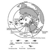
And this raises the question as to how the dinosaurs which reproduced through eggs lived and reproduced in the Polar Regions? It is impossible for reptiles like dinosaurs to live and reproduce through eggs in the Polar Regions which are now snow covered.Hence, with the fossils of dinosaurs found in the Polar Regions, it has been categorically proved that during the era of dinosaurs, a temperature similar to the one found in the equatorial region must have prevailed in the Polar Regions also. Similarly, due to the earth’s axial tilt of twenty three and a half degrees, the Polar Regions have a six month period of continuous daylight and nearly six months of night. If night continues for a period of six months, in the absence of sunlight, plants cannot perform photosynthesis and survive. Hence, the axial tilt of the earth must have occurred only after the extinction of dinosaurs.
Some researchers have said that the arctic dinosaurs may have
survived month long darkness by eating rotten plants.
but researchers has said that dinosaurs went
extinction due to the month long darkness and cold created by the collision of
space rock with earth which caused massive loss of vegetation on which
dinosaurs feed on. This is quite contrary to the previous explanation.
Similarly, some
researchers has said that the dinosaurs may have migrated to south to lay eggs,
but fossils of dinosaurs eggs has been discovered in the northern Siberia, but
Gregory M.Ericson of Florida university, who conducted a research and said that
the dinosaurs eggs took six months to hatch, and the baby dinosaurs took more
than one year to grow, therefore he concluded the dinosaurs did not take
migration and lived in the arctic. Therefore the dinosaurs fossils discovered
in the arctic proved that the arctic experienced tropical climate during the
dinosaur’s period.
Even today the
occurrence petrified tropical fossils in the Arizona is explained by the so
called plate tectonic theory. But this kind of explanation is absolutely failed
to explain the dinosaur’s fossils of the arctic region.
Therefore the plate
tectonic explanation said for the occurrence of crocodile fossils in the
Arizona is wrong.


chapter-2/6 The explanation said for the presence of animals on the island is not
trustworthy.
when an oil rig was drilled in the seabed near Norway , at a depth of two kilo meters, the bone fossils of dinosaurs which lived twenty million years ago, were found in the rocky pieces and were brought above.
From the bone fossils of dinosaurs that have been discovered, it is clearly proved that during the period of dinosaurs, the sea level had been two kilo meters lower.
From the bone fossils of dinosaurs that have been discovered, it is clearly proved that during the period of dinosaurs, the sea level had been two kilo meters lower.
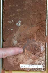
Norwegian researchers discovered the fossils of dinosaurs from the rocks that were unearthed while drilling an oil well under the sea using drilling machines.
Morten Bergan and Johan Petter Nystuen two Geologists of Norway discovered the fossils of dinosaurs which were three centimeters long from the rocky pieces which were unearthed while drilling into the rocks, at 2.3 kilometers depth under the sea and one hundred and forty kilometers on the western side away from the Norwegian Sea shore.
Norwegian palaeontologist Doctor Jorn Harald Hurum of the Oslo University, who studied the fossils under a very powerful microscope, found out that the fossils belonged to a species of dinosaurs called Plateosaurus which lived in abundance in the continent of Europe, 200 million years ago.
To state specifically, the dinosaurs called Plateosaurus were huge gigantic animal of four ton weight and with the capacity to grow thirty feet in length. Till then, the fossils of dinosaurs had been discovered only on the surface of the earth.
Now, for the first time the fossils of dinosaurs have been discovered in rocks under the sea, that too two kilometers below the sea level, which proves that during the time of dinosaurs, the sea level was two kilometers lower than it is at present.
Hence, the reason for the presence of the fossils of dinosaurs on all the seven continents is that, during the time of dinosaurs the sea level was two kilometers lower than at present.
But, it is wrongly believed that, originally all the seven continents were fused together and later got detached and they are still moving away from each other and so, the bone fossils of dinosaurs are present on all the seven continents.
Similarly,rocky fossils excavated from a submerged plateau (which formed twenty million years ago,) in the Indian Ocean at a depth of two kilo meters below sea level, contained the remains of burnt parts of trees, seeds and pollen grains.
Hence, the explanation offered for the bone fossils found on the continents that the continents and islands were once upon a time fused together and later got separated and are moving away is unacceptable. The real reason is that, the sea level had been two kilo meters lower and there had been land links by which the animals were able to spread.
Similarly new seafloor is believed to be formed
continuously and spreading in to opposite direction all along the mid Atlantic
ridge. If that is the case, then the age of the rock in the mid Atlantic ridge
must be younger than the rock near the edge of the continents.
Similarly the rock which is near the Gakkel ridge, which
is otherwise called as the mid ocean ridge of the arctic, from where new ocean
floor is believed to be form and spreading opposite direction, also dated 2
billion years old. This also proved that the sea floor spreading hypothesis is
just a misconception.
Further to state, volcanic chains are believed to be form
on the continents as well as on the sea floor, as they moved over hot spot
volcano. If that is the case, then the volcanic chain that formed on the sea
floor as well as on the continents must be parallel to each other.
But contrary to
the expectation, the volcanic chain that formed on the northwestern part of the
North American continents, called as Anaheim, Stikine, and wells gray, which
are formed in the same period, formed in different direction. This proved that
the North American continent is a fixed formation,
Similarly, the ‘Line Islands’ which is formed on the
pacific seafloor is not parallel with the Hawaii island chain. This proved
that the pacific sea floor is a fixed formation.
Fossils of Hippopotamuses on the island of Madagascar.


Hippopotamuses are animals which evolved in the continent of Africa twenty million years ago.
Hippopotamuses cannot swim in water. It is important to state that they cannot even float in water as they are animals weighing three thousand kilos.
When this is the situation, the bone fossils of a dwarf variety of hippopotamuses were found in the island of Madagascar which is four hundred kilo meters off the continent of Africa .
Based on the fossil findings, it has been found out that these animals had been weighing four hundred kilos.
Eminent Zoologists have stated that these dwarf hippopotamuses would have evolved from the large hippopotamuses which reached these islands many millions of years ago.
It is important to state that the continent of Africa and the island of Madagascar are separated by a sea of two kilo meter depth.
Similarly, the bone fossils of dwarf hippopotamuses have been excavated from the islands, Cyprus , Sicily , Malta and Gritty of the Mediterranean Sea area.

But, scientists have accepted that they are not aware as to how hippopotamuses would have reached the island of Cyprus .
Hippopotamuses which could not swim, must have reached the islands only by land.
Based on the bone fossils of a dwarf species of hippopotamus, it has been found out that twenty million years ago the sea level was two kilometres low.
The pygmy hippopotamus is a species which evolved in the African Continent.
Being the third largest animal next to elephant and rhinoceros, this animal cannot float or swim on the surface of the water.
Recently, bone fossils of three species of pygmy hippopotami have been discovered on the island of Madagascar situated at a distance four hundred kilometers from the African Continent.
It was also discovered that these animals were weighing four hundred kilograms.
Based on this finding, the zoologists believe that these pygmy hippos accidentally landed on the island of Madagascar thrice by clinging on to the branches of trees, which floated from the African Continent.
At the same time, bone fossils of different species of pygmy hippopotami have been discovered in the islands of Sicily, Crete, Malta and Cyprus situated in the Mediterranean Sea.
Particularly, it is believed that the dwarf species of hippopotami which inhabited the islands of the Mediterranean Sea was only the offspring of a full-sized species of Hippopotamus called Hippopotamus antiques, which lived in the European Continent.
It is explained that the full-sized hippos which reached the islands of the Mediterranean Sea by clinging to the floating tree branches, shrunk through the process of insular dwarfism due to the limited food environment in the islands.
But this explanation is baseless.
The reason is, after these full-sized hippos reached the islands of Mediterranean Sea by clinging to the floating tree branches, at least one male and one female hippo must have arrived at the island to trigger the hippo population there. This is an unusual explanation.
In the absence of which, at least one pregnant female hippo must have reached the islands and after the birth of two calves, this species must have thrived.
But, the hippos usually give birth to one calf only.
Very rarely, hippos have given birth to twin calves.
It is a baseless theory that the hippos which accidentally arrived at the four islands of Sicily, Crete, Malta and Cyprus situated in the Mediterranean Sea by clinging to the floating tree branches, had unnaturally given birth to twin calves in each of these islands.
Similarly, on the basis of the discovery of bone fossils of three species of pygmy hippopotami at the island of Madagascar, it is believed that hippos from the African Continent must have reached this island thrice by sea by clinging to the floating tree branches.
It is meaningless to state that the hippos which accidentally arrived from the African Continent thrice by clinging to the floating tree branches had unnaturally given birth to twin calves every time.
To be precise, the hippos could not have arrived accidentally at the four islands situated in the Mediterranean Sea four times from the European Continent and arrived at the island of Madagascar thrice from the African Continent, by clinging to the tree branches floating in the sea. After arriving there in such a way, it is beyond anyone’s imagination that the hippos could unnaturally give birth to twin calves all the seven times.
Hence, the fact that the bone fossils of different species of pygmy hippos have been discovered in the four islands of Sicily, Crete, Malta and Cyprus, it has been proved with evidence that twenty million years ago, the sea level was two kilometers low and there was a land link between the continents and the islands.
The extraordinary journey of snails.


In the continent of Europe , Balea snails which have a very small nut like shell are found sticking to the trees. These snails are found on “ Azores ”, a volcanic island which is in the central region of North Atlantic Ocean , one thousand five hundred kilo meters away from the continent of Europe .
Dr. Richard Breeze of Cambridge University says that these snails could have stuck to the legs of birds and reached the island. This explanation sounds extraordinary because birds are in the habit of cleaning themselves often.
The same species of snails which are found on the northern hemisphere on the island, Azores situated in between North America and Europe in North Atlantic Ocean is Also found on the volcanic island of “Tristan de Cunha” in the southern hemisphere between the continents, South America and South Africa in the central part of South Atlantic Ocean which is nine thousand kilo meters away from Azores .
So, the explanation which states that these Balea snails would have stuck to the legs of birds and reached Azores becomes questionable. It is because, the theory of Balea snails had moved from one island to another by following the same method of clinging to the legs of birds sounds unacceptable.
Then how could these snails have spread in both the islands?
To be specific, both these islands are the highest peaks of a mountain range which starts from the northern hemisphere and extends to the southern hemisphere below the sea and protrude above the surface of the Atlantic Ocean .
This under sea mountain range is eight thousand feet above the sixteen thousand feet deep sea bed of the Atlantic Ocean . But, it is six thousand feet below the sea level.
As already known through different kinds of evidence, twenty million years ago when the sea was ten thousand feet lower than it is now, this under water mountain range was four thousand feet higher. So, Balea snails found on “Azores”, a volcanic island which is in the central region of North Atlantic Ocean, traveled by land and reached the volcanic island of “Tristan da Cunha” in the central part of South Atlantic Ocean.
After this, as the sea level rose ten thousand feet, the mountain range which was above sea level got submerged in the sea.
So, Balea snails did not cling to the legs of birds and reach the island by air but in fact, twenty million years ago they traveled on the Atlantic mountain range which was above the sea level and reached the island of “ Tristan da Cunha ” from the island of Azores .
The Extraordinary sea voyage of frogs.
From the body of the thin skinned frog, water will get easily evaporated. This will cause the death of the frog. To prevent this, the skin of the frog will always be moist. In spite of this natural protection, the frog comes out only in the rainy season. It always lives in wet shady areas and avoids too much of sun and windy places. To be specific, frogs will not move far away from water bodies.
When it is so, Dr. Blair Hedges of the Pennsylvania University has found out through DNA test that, the frogs found in the Caribbean Islands had their ancestors in the continent of South America .
But, these ancestors would have traveled from South America to Caribbean Islands on sea plants which was washed out into the sea by the force of rivers and they would have had insects to eat and water to drink on those sea plant – says Hedges.*(10)
But, as the Atlantic Ocean’s level was ten thousand feet lower, the frogs have traveled from South America to the Caribbean by land through the connection that existed then. After the land rose, South America and the Caribbean also rose.
Animals on islands-a mystery
In 1931, when Charles Darwin visited the Falkland Island in the Atlantic Ocean , situated 500 miles away from South America , he found a new species of wolf moving about freely without any fear on the island and he was surprised.
The wolf gave them surprised looks as if they had never seen human beings before.
Till this day, it has been very puzzling as to how these creatures came to be on that isolated island.
Can animals cross the ocean?
Animals which have pouches to carry their young like the kangaroo are called marsupial mammals. As the fossils of these marsupials were found in the continents of North America , South America and Antarctica , it was concluded that these animals migrated from North America through the continent of Antarctica to Australia . But, recently the bones of the ancestors of kangaroos which lived 125 million years ago have been unearthed in China .
Researcher Tom Rich of the Victoria museum of Melbourne city says that this opens a new vista regarding the evolution of mammals. This strengthens the view that from China these kangaroos could have gone to Australia and the sea level had also been very low to help these animals to move from one continent to another.
Did monkeys cross the Atlantic Ocean ?
According to Wagner’s theory of moving continents, it was believed that 150 million years ago South America was detached from the continent of Africa , moved towards west and reached the position in which it is now situated. Researches show that only 3 million years ago the land of Panama appeared between North America and South America and united both these continents.
Wagner’s theory states that till then South America was an island continent. Recently the jaw bones of a monkey which lived 20 million years ago have been found in Andes Mountain at South America . After examining the teeth, researchers have stated that this species of monkeys originated in Africa .
At present, the DNA tests conducted on the monkeys living in South America also showed that their ancestors reached there from Africa . (Researcher Diane Rowe of Massachusetts University said that even the rabbit like animals living at present in America traveled on the Atlantic using floating plants and logs and reached here from Africa ).
The problem here is, researcher John Flynn of the Chicago city museum states that the ancestors of these monkeys traveled on floating plants and logs 20 million years ago and crossed the 2000 miles broad Atlantic Ocean and reached here. Moreover we were under the impression that the Andes Mountain originated 100,000,000 years ago.
The recently discovered bones have made us understand that it originated later and the theories about the formation of Andes have completely changed. But, as the sea level was very low, there is a possibility that from Africa these monkeys could have reached South America by land. Moreover the DNA tests conducted on monkeys found on Jamaica also revealed that they were from Africa . So, it is clear that the sea level had been very low many million years ago.
chapter-3/6 - Iguanas in the centre of the Pacific Ocean.


In the afternoon, when the heat of the sun increased, a few of the iguanas regained consciousness and climbed the trees. Most of the other iguanas were crushed under the wheels of vehicles that passed by. This incident was telecast as ‘iguana rain’ by a local television channel.
When such is the case, how could the iguanas have traveled day and night in the sea and reached these islands along with floating vegetation?
Before diving into the sea to feed on the moss found in the sea, the iguanas living on Galapagos Islands lie down on the rocks found on the sea shore up to noon to increase their body temperature.
Then they dive into the sea to feed on the moss and after consuming, once again lie down on the rocks to regain the lost temperature. Some times, the iguanas lie close together to keep themselves warm. It is note worthy that during the night, the iguanas burrow into the sand and keep themselves warm.
The archeologists who evaluated the rocks of the Galapagos Islands have found out that the rocks have been formed four million years ago. Based on their findings, the archeologists have discovered that the Galapagos Islands have been formed only four million years ago.
But, according to the DNA testing, it has bee found that, the iguanas evolved from a common ancestor before twenty million years. Hence, it is really puzzling to note that the iguanas living on Galapagos Islands seem to be older than the islands themselves.
Researchers are of the opinion that long before their migration to Galapagos Islands , the iguanas living on Galapagos Islands could have lived on some other islands for millions of years. Researchers have stated that, those islands would have sunk in the sea and they might be re-discovered later.
In the mean time, geologists have collected and tested rock samples from the volcanoes which are found submerged at 6,500 feet below sea level in the sea between the continent of South America and Galapagos Islands . Researchers discovered that the rock samples collected from the volcanoes submerged at 6,500 feet below sea level unlike the volcanic rocks above ground level, did not contain carbon in them.
Based on their findings, researchers have found out that, the volcanoes which are found submerged at 6,500 feet below sea level in the sea now, have been volcanic islands above the ground level millions of years ago. Moreover, the researchers had seen marks of erosion on a rock near a submerged volcano by sea waves and also pebbles. All these show that, thousands of years ago, the level of the sea had been 6,500 feet lower and those volcanoes had been islands above the sea level.
Hence, it is proved that millions of years ago, when the level of the sea between the continent of South America and Galapagos Islands was thousands of feet lower, along the land connection iguanas had migrated from South America to the Galapagos volcanic region.
Like the iguanas, giant tortoises too had migrated from South America to the Galapagos volcanic region along the ground connection. Later when the level of the sea rose, Galapagos volcanoes came to be known as Galapagos Islands .
Iguanas in the center of the Pacific Ocean
To state specifically, Fiji Island , which is at a distance of eight thousand kilometers away from South America , has two different species of iguanas namely, Brachylophus vitiensis and Brachylophus fasciatus.
How were the iguanas able to cross a sea stretch of eight thousand kilometers?
Researchers believe that, these iguanas would have reached Galapagos Islands which is 1000 kilometers away from the continent of South America along with huge branches of trees or plants which were floating for about two weeks in the sea.
When things stand thus, how the iguanas survived with out food and water during the journey for a minimum of 16 weeks that is, a little more than one year to Fiji Island , which is at a distance of eight thousand kilometers away from South America in the center of the Pacific Ocean ?
Crossing eight kilometers of sea, on floating vegetation and branches of trees would take many months. But, iguanas could not have traveled on floating vegetation and branches of trees for many months and reached Fiji Island from South America .
Hence, the presence of iguanas on Fiji Island , which is at a distance of eight thousand kilometers from South America in the center of the Pacific Ocean , clearly shows that, thousands of years ago the level of the Pacific Ocean had been ten thousand feet lower than what it is at present.
Just as the iguanas had migrated along the ground connection from the continent of South America to the Galapagos volcanic region, they also migrated along the mountains found above the Pacific Ocean from the continent of South America to Fiji Islands .
Iguanas known as “Coloradoan Madagascariensis” are found on Madagascar which is situated 400 kilo meters away from the continent of Africa . But, it should be noted that, iguanas are not found in the continent of Africa and Asia or the continent of Europe . Iguanas are found only in five places on the earth.
They are, South America , Galapagos Islands , Caribbean Islands , Fiji Islands and the island of Madagascar . How did the iguanas spread to these five places which have no connection with each other?
The iguanas which have been sighted on the continent of South America are not only found on the Galapagos Islands on the eastern side of the Pacific Ocean, but also on Fiji Island which is in the center of the Pacific Ocean and the Island of Madagascar on the other side of South America and in Indian Ocean. The main reason for this is that, millions of years ago, when the level of the sea was thousands of feet lower than it is at present, the central mountain range which is submerged at present at a depth of six thousand feet was a continuous range above the sea level.
When the central mountain range, which is submerged at present at a depth of six thousand feet was found continuous above the sea level thousands of years ago, the giant tortoises, iguanas, different species of lizards and mammals including the foxes had migrated from one place to another.
Later, the sea had risen up. The frogs and lizards present on the different islands show that thousands of years ago the level of the Pacific Ocean had been thousands of feet lower than what it is at present.
How did earthworms reach the islands?

From Galapagos Islands Darwin next reached Island of Tahiti which is in the central part of the Pacific Ocean . Darwin learnt that on Tahiti lived rare species of earthworms which were not found on any other part of the world.
Darwin stated as follows in his book:
“Earthworms are present in large numbers on many isolated islands and on Iceland . It has been found that, they are also spotted on West Indies Islands , Saint Helena , Madagascar , New Caledonia and Tahiti .
Researchers have already explained about the earthworms found on Kerguelen Island . Darwin had stated that he had seen earthworms on the Island of Falkland .
Unlike millipedes, earthworms do not have legs. Hence, earthworms cannot climb on trees or plants or creepers like the millipedes do. Similarly, the mucus secreted by earthworms is not sticky like that of the mucus of snails. So, earthworms could not have reached the islands by getting stuck to leaves or dry leaves which can glide along with wind.
It should be noted that earthworms are living things that breathe with their skin.
When the air in between soil particles is attracted by the slimy secretion from the body of the earthworm, the oxygen in the air penetrates the skin and gets mixed with its blood. Similarly, the carbon-dioxide in earthworm’s blood is eliminated through the skin and mixes with the air outside and breathing takes place.
If the earthworm remains in the air for a long time, the moisture on its body will dry up and it cannot breathe. Similarly, the earthworm’s body dries up in sunlight and so it cannot survive.
Hence the earthworms come above the soil only in the evening and night. During rains also earthworms come above the soil. The moisture on the earthworm’s body will be intact in the evening, night and during rain.
Hence, the earthworms could not have traveled on floating plants and branches of trees for many days and reached the islands.
The earthworms could not have survived the sun and the wind for many days and reached the islands. So the presence of rare species of earthworms in Tahiti, which are not found in any other part of the world shows that, thousands of years ago the level of the ocean had been thousands of feet lower than what it is at present and had provided a link between the continents and islands.
Apart from this, earthworms and their eggs are capable of absorbing the salt in the sea water. If such a thing happened, the earthworms would die. Based on this, Dr. Frank E. Beddard, who discovered many species of earthworms has stated in his book’ “The opinion that the earthworms would have traveled on floating plants and reached the islands cannot be accepted.”

Surrounding the continent of Antarctica , each of the volcanic islands namely, Falkland , Kerguelen, Saint Georgia , Crozet, Macquarie , Campbell and Auckland have their own rare species of earthworms which can only be seen in each of these islands.
How could the earthworms, which cannot migrate along with the wind or float along with floating plants, have reached the different volcanic islands found many hundreds of kilometers apart, surrounding the continent of Antarctica?
Many thousands of years ago, when the level of the sea was thousands of feet lower, there should have been a link between the continents and the present day islands which were once volcanoes and the earthworms would have migrated to the different islands through that land link.
A type of earthworm, known as Microscolex, which is a native of the continent of South America is found on the different volcanic islands surrounding the continent of Antarctica. So, the presence the earthworm, known as Microscolex on these islands proves that, many thousands of years ago there should have been a land link between the continent of South America and the different volcanic islands surrounding it.
The submerged continent
On the extreme southern end of the Indian Ocean , near the continent of Antarctica , is the island, Kerguelen on which a rare variety of earthworms called Microscolex are found.
For a long time, it has been a puzzle as to how the earthworms would have reached the volcanic island Kerguelen, which is situated in the center of a rough sea.
At the same time American researchers started to probe, when the volcanic island Kerguelen came in to existence.
The island of Kerguelen is a volcano, which is located on a flat plateau at a depth of two kilometers below the sea level. Researchers collected rocks formed by the molten rock material, which had oozed out of the central portion of the under sea plateau which is known as the Kerguelen plateau and conducted a study.
Then, it came to light that those rocks had been formed twenty million years ago. In addition, the researchers also discovered in those submerged volcanic rocks, the fossils of burnt parts of trees, seeds and pollen grains.
Based on these findings, Dr Mike Coffin of the University of Texas , also the head of the research team stated that, twenty million years ago this under sea plateau had been an island above the sea level.
So, it has been proved by the fossils of trees from the under sea Kerguelen plateau that twenty million years ago the level of the sea had been two kilometers lower than it is at present.
So, the presence the South American earthworm, known as Microscolex, on the volcanic island of Kerguelen, formed from the under sea Kerguelen plateau two kilometers above sea level, also goes to proves this.
Hence, as the sea level had been two kilometers lower, the earthworms had migrated from the land of South America to the Kerguelen volcanic region.
It is possible for earthworms which live in the soil, to migrate from one place to another along the land.
Hence, by the presence the South American earthworms on the volcanic island of Kerguelen and the fossils of trees from the central part of the undersea Kerguelen plateau which is submerged two kilometers below the level of the sea, it has been proved beyond doubt, that the sea level had been two kilometers lower twenty million years ago.
chapter-4/6 – Geologist don’t
know what is actually happening on the sea floor.

It has been proved with evidence, that the explanation offered by the geologists presently for the occurrence of earthquakes and tsunamis is wrong.
Particularly, the geologists believe that at present, the continents are drifting as separate tectonic plates along with the ocean floor.
The geologists explain that earthquakes are caused only due to the rubbing of the edges of the tectonic plates that drift apart along with the ocean floor.
The geologists explain that in a similar way, when the tectonic plates are drifting under the sea, one rocky plate beneath another moves scraping against the one above it and this causes the upper rocky plate to rise suddenly pushing up the sea water giving rise to tsunami waves.
But, all these explanations have been proved as baseless by a global seismic chart showing lakhs of places worldwide where earthquakes occurred.
Also, the satellite photographs which capture the variations of the floor level with precision have also revealed the occurrence of earthquakes and tsunamis due to the eruption of underground volcanoes.
Before studying these evidences, it is essential to review the explanations offered by the geologists.
The geologists believed that specifically two hundred and fifty million years ago, prior to breaking up and drifting to their present locations, all the seven continents had at one time formed a single supercontinent which was called Pangaea.
The geologists also believed that this supercontinent was surrounded by a deep sea area.
The geologists believed that later, hot magma from beneath the Pangaea supercontinent gushed to the top, cooled and solidified and this magma went back into the earth due to its increase in weight.
They also believed that this magma, which was found thousands of kilometers under the earth, rotated like wheels in the opposite directions and caused the super continent above to break up into two.
The geologists also believed that this led to the formation of two large continents namely Laurasia and Gondwana a hundred and eighty million years ago, of which Laurasia drifted towards the northern region and the continent of Gondwana drifted towards the southern region.
The geologists believe that an ocean area called Tethys formed between these continents, i.e., in the equatorial region.
The geologists also believe that eighty million years ago, the continent of Laurasia also split into two, leading to the creation of the continents of North America and Eurasia, which moved in the opposite directions of west and east respectively.
They also believed that as a result of the above, the North Atlantic Ocean region was formed between these two continents.
The geologists also believe that in a similar way, after the split of the southern region of the continent of Gondwana into many parts, these continents drifted towards the north.
Further, they also believed that particularly, due to the split in the western part of the continent of Gondwana, the continents of South America and Africa were formed and due to their respective drift towards north-west and north-east directions, North Atlantic ocean region emerged between these two continents.
The geologists believed that the South American Continent which was drifting towards north-west reached its current location only three million years ago.
In the same way, the geologists believe that the Alps mountain range came into being due to the thrusting of the land region between the African and Eurasian Continents caused by the collision of the African Continent which was said to be drifting towards north-west, with the southern part of the European Continent.
The geologists also believe that in a similar way, India and Australia also broke away from the Continent of Antarctica and drifted in the north-eastern direction.
The geologists believe that due to the collision of the Indian land area with the southern part of the Asian Continent fifty million years ago, Himalayan mountain range rose between these two continents by thrusting.
The geologists believe that even today, the magma under the earth becomes solid after reaching the surface, forming a new sea floor in the volcanic range under the sea that extends in the north-south direction, and is drifting in the opposite directions causing the continents on both sides of the Atlantic Ocean also to drift apart in the opposite directions along with the ocean floor.
The geologists are also of the opinion that when the continents drift separately along with the ocean floor, friction is caused between their edges and earthquakes are caused.
At this point, the geologists of NASA, the leading scientific research center of America, prepared a graphical representation of the places world-wide where a total of 3,58,214 earthquakes occurred during the past 35 years from the year 1963 to 1998.

This global level graph on earthquakes had not recorded any continuous earthquakes in the ocean region between the North American continent formed in the central part of the Atlantic Ocean and drifting towards north with the ocean floor believed to be drifting towards north and the South American continent formed in the central part of the Atlantic Ocean and drifting towards north-west with the ocean floor believed to be drifting towards north-west.
Hence, on the basis of the absence of continuous earthquakes in the ocean floor area between the North American and South American continents, it has been proved with concrete evidence that the ocean floor between these two continents is continuous and the ocean floor between these two continents as well as the North American and South American continents are stationary.
Similarly, it is proved with evidence that the geologists of the American Geological Association, which is known as USGS, had offered a baseless and fictitious explanation when an earthquake and tsunami rocked Haiti, an island situated in the Caribbean group of islands on 12.01.2010.
Particularly, the Continent of North America, formed in the central part of the Atlantic Ocean is believed to be moving towards west along with the ocean floor which is supposed to be drifting towards west.
In the same way, the Continent of South America, formed in the central part of the Atlantic Ocean is believed to be moving towards north-west along with the ocean floor which is north-west to be drifting towards north-west.
Under these circumstances, a question arises as to how exactly the Caribbean group of islands, which is located between these two continents, was formed.
Some geologists believe that the Caribbean group of islands would have formed due to volcanic activity in the Pacific Ocean region a hundred million years ago, particularly at the place where the Galapagos group of islands is situated now, and later the Caribbean group of islands formed into a separate tectonic plate and started moving towards east.

Under these circumstances, some geologists believe that the American Continents moved separately in opposite directions towards west and during that period, the bridge-like Central American land area had not formed between the continents. On account of this, a gap existed between these continents and the Caribbean tectonic plate entered into this gap. Later, the Central American land area rose from under the sea and this created a land connection between the continents.
According to this theory called “The Pacific Model”, it is believed that the Caribbean group of islands might be moving towards east.
Particularly, in the eastern region of the Caribbean group of islands, volcanic mountain ranges have formed towards the north-south direction.
As per the “The Pacific Model”, an explanation is offered for the formation of volcanic mountain ranges towards the north-south direction in the eastern region of the Caribbean group of islands.
It says that, when the Caribbean group of islands was moving in the easterly direction, the Atlantic Ocean floor heading towards the west went under the tectonic plate, melted due to the extremely high temperature and the magma thus formed rose up penetrating through the ocean floor and became volcanic mountains above the ocean floor.
Further, the geologists also believe that, ninety million years ago, the bridge-like continuous Central American land area had not formed between the American continents. During that period, a gap existed between these continents and the Caribbean tectonic plate entering into this gap has been the reason for their present location.

However, in 1971, Gregory S Horni and Bruce Simonson have discovered in the mountainous region of Nicaragua which is situated at the Central American land area, the bones of a dinosaur called Ornithopod that lived ninety to a hundred and twenty million years ago during the mid-cretaceous era.
Geologist Professor Joan Ostram of Yale University, after examining the bones of the dinosaur, has identified and confirmed that these bones, now kept in the Washington Museum, belong to a dinosaur called Ornithopod.
This has proved with evidence that the land region of Central America situated between the American Continents was continuous even before ninety million years and the dinosaurs were migrating between the American Continents through this region.
in the same way, Manuel Ilduraldy Vincent and Zulma Gasparini , paleontologists of the Cuban Museum has discovered the bone fossils of a herbivore dinosaur that lived during the cretaceous era, i.e., a hundred and fifty million years ago, in the Organos mountain range located in the western part of Cuban Island of the Caribbean group of islands that are formed in a range between the American Continents.
Through this, it has been proved beyond doubt that as the sea level was low a hundred and fifty million years ago, the American Continents and the Caribbean group of islands had land connections and the dinosaurs were migrating through that region.
As a result, it has been proved with evidence that the explanations offered by the geologists saying that ninety million years ago, a gap existed between the American continents and the Caribbean tectonic plate entered through it were baseless and imaginary theories.
At this point, some other geologists have a notion that the Caribbean group of Islands might have formed in the Atlantic Ocean region itself and moving in the western direction, they might have reached the current location.
This theory is called “The Atlantic Model”.

But, there is no evidence for the presence of a significant number of volcanic mountains in the Atlantic Ocean region similar to those present in the Galapagos group of islands in the Pacific Ocean region. So, the geologists in favor of “The Atlantic Model” could not explain where exactly in the Atlantic Ocean region did the Caribbean group of Islands form.
Hence, the geologists who support the Atlantic Model believe that the volcanic eruptions responsible for the formation of the Caribbean group of Islands might have disappeared over time.
However, the geologists who believe in the theory of “The Atlantic Model” are unable to explain how the volcanic mountain ranges in the eastern part of the Caribbean islands facing the north-south direction came into being.
Under these circumstances, a few other geologists have offered a new theory that the Caribbean group of islands might be an in situ model.

Hence, it boils down to the fact that the geologists, who state that the Caribbean group of islands is drifting as a tectonic plate, have no idea as to where the Caribbean group of islands was formed and in which direction it is heading.
At this juncture, the geologists of the American Geological Association, which is known as USGS, had offered a baseless explanation for the earthquake and tsunami which rocked Haiti, an island situated in the Caribbean group of islands on 12.01.2010 that the earthquake in Haiti was caused only by the friction between the tectonic plates during the movement of the American and Caribbean tectonic plates.
Specifically, the geologists of the American Geological Association, which is known as USGS, believe that the Caribbean group of islands is drifting as a tectonic plate, but since the geologists of the USGS Association do not know where the Caribbean tectonic plate was formed and in which direction it is heading, they avoid any direct mention of where the Caribbean tectonic plate is heading and state that the North American Continent is drifting towards west and on account of this movement, the Caribbean tectonic plate is moving towards east with respect to the North American Continent. The geologists of the USGS organisation explain that this caused friction between the tectonic plates resulting in the occurrence of earthquake and tsunami in the Island of Haiti.

How can this be a correct and acceptable explanation?
In fact, it is a truth that the geologists of the USGS organization are not aware of what is happening in the ocean floor region between the American Continents.
To conceal their ignorance, the geologists of the USGS organization have given an ambiguous explanation regarding the direction in which the Caribbean tectonic plate is drifting, thereby tactfully avoiding a direct reply.
This has brought to limelight that the geologists of the USGS organization are ignorant of the reason for the occurrence of earthquake and tsunami in the Island of Haiti.
The fact, it has been proved with evidence through a global seismograph, that the ocean floor and the continents are stationary and the ocean floor region between the continents is continuous.
Also, the fact that that the earthquake and tsunamis were caused only by volcanic eruptions below the surface of the earth has been discovered through the images captured by a satellite.

Similarly, the geologists believe that a hundred million years ago, India and Australia were joined together and stuck with the continent of Antarctica. Later, new ocean floor was formed around the continent of Antarctica and it drifted towards north and south directions. India and Australia started to move in the north direction along with the ocean floor that was drifting towards north.
India and Australia are located five thousand kilometers apart.
If India and Australia were together in the beginning and had drifted five thousand kilometers apart as per their location today, these two continents must have been moving on two separate ocean floors.
If India and Australia had been drifting separately towards north-eastern direction, a series of earthquakes would have been caused for up to thousands of miles in the ocean floor between these two continents.
But, no such series of earthquakes was recorded in the ocean floor area between those two continents in the global seismograph published by NASA.

Thus, on the basis of non-occurrence of a series of earthquakes in the ocean region between the continents of India and Australia, it is proved with the concrete evidence that the ocean floor between these two continents is continuous and the ocean floor and the continents between these two continents are stationary.
At this juncture, NASA released a chart stating it as an illustration of the movement of the continental plates.
Even in that chart, it has been stated that they are still unsure as to what is actually happening in the ocean floor region between the continents of India and Australia.


Moreover, they have offered contradictory explanations for the tsunami that rocked the entire South Asia on 26.12.2004.
Particularly, in the report released by NASA on 10.3.2005, Dr. Richard Cross and Dr. Benjamin Bang Cho have explained that the earthquake and tsunami were caused only due to the sudden drifting of ocean floor of the Indian Continent under the Indonesian Islands.

But, in the report released by NASA after three months, i.e., on 27.4.2005, the geologists of NASA had stated that the earthquake and tsunami were caused only due to the sudden drifting of ocean floor of the Australian Continent under the Indonesian Islands.

Thus, it is proved beyond doubt that the geologists of NASA have offered an imaginary explanation for the earthquake and tsunami on the basis of a mere hunch, without knowing what was actually happening in the ocean floor area between the two continents.
chapter-5/6-Tsunamis are caused by the eruption of underground volcanoes.


When a research team headed by Dr. Juliet Biggs, a seismologist of Miami University studied four
volcanoes in the eastern region of Africa through a satellite that recorded the ground level variations
by using radio waves, it was found that rugged rings of a few centimetre heights had formed around
these volcanoes in a circumference extending to many kilometres.
Dr. Juliet Biggs cited the upward and downward movement of the volcano as the reason for the
formation of these rugged structures around the volcano.
Particularly, when a volcano rises due to the accumulation of magma underneath, the ground that
surrounds the volcano also tends to rise a few centimetres along with the volcano.
Similarly, when the volcano settles down after the gases and steam are expelled, the land area that
had risen along with it in a circular form also settles down and this causes rings of scar-like ups and
downs around the volcano.

During the same period, in 2009 when a severe earthquake occurred in L’Aquila situated in the
central Italy, the satellite that recorded the ground level variations, captured the rings of ups and
downs with a height and depth of a few centimetres that were similar to those formed around the
epicentre of the earthquake extending to a circumference of several kilometres.
Moreover, a scientist known as Giampaolo Giuliani who is engaged in a research for predicting
earthquakes beforehand, had discovered the emission of a radioactive gas called Radon from below
the earth in that earthquake region a week before the occurrence of the earthquake.
Most importantly, Radon is a gas emitted by volcanoes.
Hence, it has been proved with evidence that the earthquake in L’Aquila was caused only by the
volcanic eruption under the earth.
Similarly, on 11.03.2011, tsunami occurred due to the earthquake under the sea near the Japanese
island Honshu.
At that time, a satellite that recorded the ground level variations had captured pictures of rings with
lots of ups and downs of a few centimetre height formed around the epicentre of the earthquake that
occurred in the Honshu island, in a circumference extending to many kilometres.


It was also recorded in the pictures of the satellite that three days before the occurrence of the
earthquake, the temperature of the upper layer of the atmosphere just above the epicentre region of
the earthquake was abnormally high.
A scientist of NASA study centre, Dimitar Ouzounov had stated that this may be due to the emission
of Radon gas in that area from beneath the earth which has radioactive properties.
Dimitar Ouzounov had explained that electrons were released from the molecules found in the air due
to radiation caused by the Radon gas and these electrons must have condensed to form an electron
cloud. As the ions formed out of this had the tendency to absorb water and this reaction is a heat
emitting reaction, it might have caused the temperature of the upper layer of the atmosphere to rise
abnormally.
Moreover, it was also recorded in the pictures of the satellite that after the earthquake, the
temperature of the top layer of atmosphere in the Honshu island had returned to it normal level.
Hence, there is an evidential proof that the earthquake and tsunami in Honshu island were caused
only by the eruption of a volcano below the surface of the earth.

Similarly, when an earthquake and tsunami rocked the Haiti Island on 12.01.2010, a satellite that
recorded the ground level variations had captured pictures of rings with lots of ups and downs of a
few centimetre height formed around the centre of the earthquake that occurred in the Haiti island, in
a circumference extending to many kilometres.
After the earthquake, the seashore of Haiti Island had risen above the sea level. This made the sea
flora in that region clearly visible.
So, it was proved with evidence that the earthquake and tsunami in Haiti island were caused only by
the eruption and uplift of a volcano below the surface of the earth.

Similarly, the Sumatra Island of Indonesia experienced tsunami due to the earthquake that occurred
under the ocean on 26.12.2004.
After the earthquake, the northern region of simeulue Island, situated near the Island of Sumatra, had
risen high up to 4 feet from the sea level.
This had made visible the flora submerged under the sea in that area.
Under similar conditions, when an earthquake shook the central part of the same simeulue Island on
20.02.2008, a satellite that recorded the ground level variations had captured pictures of rings with
lots of ups and downs of a fifty one centimetre high, formed around the epicentre of the earthquake
that occurred in the simeulue island, in a circumference extending to many kilometres.
Hence, it was proved with evidence that the South Asian tsunami was caused only by the eruption of
a volcano below the surface of the earth.
Conclusion
Researchers cannot give explanation for the distribution of
fossils on the basis of plate tectonic theory.
Similarly, Researchers cannot give explanation for the earthquakes
and tsunamis that devastated the islands of the Indonesia, Haiti, and the
Honshu on the basis of plate tectonic theory.
In this stage, sat images clearly indicate, that the
earthquakes and tsunamis that devastated the islands of the Indonesia, Haiti,
and the Honshu were formed by the eruption of underground volcanoes.
chapter-6/6-Sea level rising is caused by the undersea hot springs.
The city of Alexandria , in which the Egyptian queen Cleopatra lived, is now found at a depth of twenty feet below sea level!
Similarly, at the sea shore of Mamallapuram near Chennai, the Pallavas constructed seven temples called Pagodas a thousand years ago. But, on the sea shore only one temple is remaining to be seen now. In the year 2004, during the tsunami when the sea receded, tourists and fisher men were able to see ruins for a distance of two kilo meters. At present these ruins are found twenty feet below the sea.
Antarctica is growing- NASA scientist.
Through satellite measurement, NASA scientist, Dr Jay Zwally, has found that the Antarctica is growing. Therefore he concluded that the melting of the Antarctica ice is not the reason for the sea level rise. He also stated that the rising of sea level is caused by some unknown reason.
A wrong explanation is given for the rise in the current sea level.
It is believed that the rise in the sea level is due to the melting of ice in the Polar Regions and this water flowing into the sea.
And it has also been found out through fossil evidence that sea level rise and snow fall have both occurred during the same period.


Particularly, in the oceanic region of the state of Florida in the North American continent, fossilized coral reefs are found at a depth of fifty to hundred meters in the rocky slopes beneath the sea.
These coral reef creatures live in the shallow part of the ocean where sunlight can penetrate. When the sea level rises, these creatures perish due to lack of sunlight. When this happens, the calcium secretions from their body turn them to fossils.
On the basis of the evaluation made on the coral reef fossils found at different levels, it was reported by the scientists that the sea level has risen by four hundred feet starting from a period prior to the past 50,000 years up to a period prior to the past 10,000 years.
Similarly, on the basis of evaluation made on the coral reef found submerged under the Australian sea region and underneath the ocean, the scientists have declared that the sea level was 400 feet below and later rose to the present level.
Also, based on the study conducted on the parts of decomposed plants and faeces of dead animals and the partly digested food in their stomach, which were found under the icy layers of the North Pole Region, the scientists of Copenhagen University reported that as the flora in the North Pole Region was destroyed due to heavy snowfall during the period beginning 50,000 years ago and ending 10,000 years back, animals like the snow elephants and snow rhinos which survived on these plants perished.
The sea level also rose up to 400 feet during this period beginning 50,000 years ago and ending 10,000 back and since the snowfall had also taken place in the same period, it has been proved with evidence that the explanation of the rise of sea level is attributed to the melting of ice is wrong.
Moreover, Steve Jacobson, a geologist of the North Western University has stated that it has been found out on the basis of a study conducted on the seismic waves, that more than three times the amount of sea water is present below the earth at the depth of six hundred and sixty kilometres.
On the basis of this theory, he has stated that the water on the surface of the earth has come from below the earth.
Prior to this theory, it was believed that the oceans were formed only due to the falling down of millions of glaciers floating in the space.
At this time, Dr. Yoshida, a geologist, analyzed the water that gushed out of the hot springs in Japan and found out from the isotopes present in it, that this water was actually separated from magma found in the greater depths of the earth.
Similarly, countless number of hot springs has been discovered beneath the sea. Hence, oceans have formed only from the water that gushed out through these hot springs for millions of years.
The theory of scientists on the formation of the ocean is wrong.
The scientists are surprised at the presence of water on the surface of the moon, particularly in its polar regions, in the form of ice.
They are also questioning as to how that water came to the moon.
As an answer to this question, the scientists believe that water might have entered the moon through the comets.
Similarly, scientists raise questions about the amount of water present in the oceans of the earth.
The reason is, presently the scientists believe that all the planets and the satellites of the Solar System, including the earth and the moon, were formed when a giant molecular cloud cooled, contracted, flattened and spun more rapidly.
Sun was formed in the bulky center of the cloud and the other planets and satellites were formed when the disk got thinner and flatter and particles of dust and gases began to stick together to form clumps.
The scientists also believe that when planets were formed in this way, the temperature near the Sun was very high and this led to the formation of rocky planets like Mercury, Venus, Earth and Mars.
Specifically, the scientists opine that since the temperature was intense in the area extending up to Mars, water was not formed in the rocky planets like Mercury, Venus, Earth and Mars.
Moreover, the temperature beyond Mars was low and the scientists believe that water was formed in the asteroids and comets formed in that region in the form of ice.
At this point, the scientists believe that oceans were formed on the earth when the asteroids and comets that strayed frequently due to the influence of the gravitational force of Jupiter, came near the earth and the moon by the gravitational pull of the Sun and fell on the earth and moon.
The ice found on these comets and asteroids were responsible for the formation of oceans on the earth.
The scientists believe that moon also got its water in a similar way.
However, the current study points out that the water found on the earth and the moon came to the surface from deep parts .
Thus, it is proved that the explanation given by the scientists for the presence of enormous amount of water on the earth and the moon, based on the Disk of Dust Hypothesis, is wrong.
Earth
is transforming into a water planet.
The
water that separates from the magma underneath the earth comes out through the
hot springs. There are innumerable hot springs under the ocean.
It is
estimated that the age of earth is 4500 million years.
The sea
level has risen by 4 kilometers in 40 million years.
But,
the discovery of the fossils of dwarf hippos at Madagascar islands proves that
within 20 million years, the sea level had risen by 2 kilometers.
At
present, the Continents are at an average height of 2000 feet above the sea
level.
In
another 10 million years, the sea level will rise to the extent of 1 kilometer
(3000 feet).
When
this happens, with the exception of Himalayas and similar rocky mountain
ranges, all other continents will lie submerged under the sea.
000000000000000
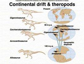
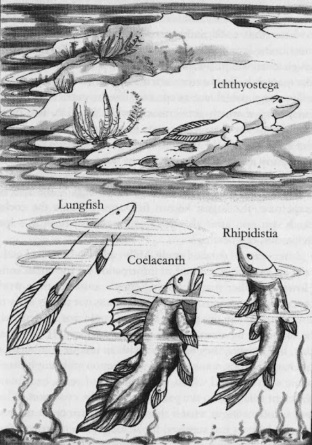
Comments